The Origin of Bowl Hill?
A couple of years ago I noticed that Bowl Hill, the road across the valley from North Woodchester which drops down from Little London to the King's Head at Kingscourt, was straight and headed directly towards Woodchester Villa. Given its apparent original end point, it seemed like it was used in Roman times, but why would Romans want to go to Little London? Investigating further, I discovered that archaeologists had found 1st century, roman military artefacts at The Hithe, on Rodborough common and had concluded that this was the site of an early Roman fort.
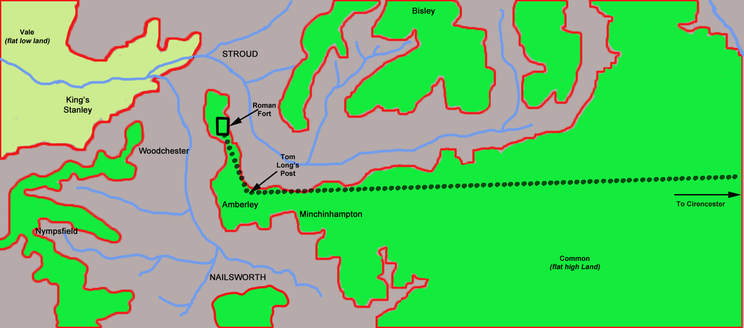
In the year 44 AD the Romans invaded Britain and about 5 years later they had built a fort at Cirencester where they based 1000 men charged with defending the then frontier. Rodborough Common would have been an obvious place to station some troops. It has good views over the five valleys and can only be reached by either climbing steep slopes or from Minchinhampton common, though the narrow gap of flat land between the current sites of the Bear Hotel and Winstone's Ice cream. This gap is less than 200m wide at its narrowest point and I imagine it would be easily defended. Interestingly, if a roman wanted to travel from Cirencester to 'The Hithe' on the flat he could follow a straight line, just touching in places the northern edge of the common until he reached Tom Long's Post. At this point he would need to head toward the top of the Bear Hill valley at the Bear and continue in a straight line to 'The Hithe'. Much of this route is on current roads and public footpaths. So was Tom Long's Post originally a Roman marker post?
A couple of years ago I noticed that Bowl Hill, the road across the valley from North Woodchester which drops down from Little London to the King's Head at Kingscourt, was straight and headed directly towards Woodchester Villa. Given its apparent original end point, it seemed like it was used in Roman times, but why would Romans want to go to Little London? Investigating further, I discovered that archaeologists had found 1st century, roman military artefacts at The Hithe, on Rodborough common and had concluded that this was the site of an early Roman fort.
In the year 44 AD the Romans invaded Britain and about 5 years later they had built a fort at Cirencester where they based 1000 men charged with defending the then frontier. Rodborough Common would have been an obvious place to station some troops. It has good views over the five valleys and can only be reached by either climbing steep slopes or from Minchinhampton common, though the narrow gap of flat land between the current sites of the Bear Hotel and Winstone's Ice cream. This gap is less than 200m wide at its narrowest point and I imagine it would be easily defended. Interestingly, if a roman wanted to travel from Cirencester to 'The Hithe' on the flat he could follow a straight line, just touching in places the northern edge of the common until he reached Tom Long's Post. At this point he would need to head toward the top of the Bear Hill valley at the Bear and continue in a straight line to 'The Hithe'. Much of this route is on current roads and public footpaths. So was Tom Long's Post originally a Roman marker post?
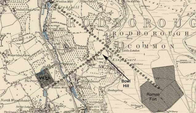
Southern England was relatively quickly subdued and the fort at Cirencester was soon surplus to requirements and was levelled in 70 AD. 'The Hithe' probably lost it military connections at this time but no doubt remained a roman settlement and there is some evidence that this was the site of a roman market. The Romans at 'The Hithe' fort would have wanted to get to Gloucester and to the roman port at Frampton and their natural route would have been to head diagonally down the hillside to the 'nose' of Selsley common, perhaps emerging at the bottom of the present Kitesnest Lane. I have shown a possible route on the 1882 O.S. map and marked the Fort/settlement as extending to the edge of the fields which were there in 1830; these were probably much earlier boundaries. My suggested route leaves 'The Hithe' from the obvious funnel between the fields and continues, largely on current sunken tracks, to Little London (where 4th century roman coins were found in 2003). Beyond this there is little clear evidence of the route although there are some old footpaths heading to the bottom of Kitesnest Lane.
Once this area became peaceful, the estate at Woodchester could develop and, over time, would have had surplus produce to sell at the market at 'The Hithe'. This would need to be carried up there for sale, however a direct route is not feasible, it is far too steep. A natural alternative would be to head towards the nearest point on the route described above, which is the top of Bowl Hill at Little London. So I think that the produce from the Roman Woodchester estate was taken across the Nailsworth stream and then up to and along Bowl Hill to Little London. From here it would continue along the main track to 'The Hithe'. This would explain why Bowl Hill heads directly toward the Villa at Woodchester.
Once this area became peaceful, the estate at Woodchester could develop and, over time, would have had surplus produce to sell at the market at 'The Hithe'. This would need to be carried up there for sale, however a direct route is not feasible, it is far too steep. A natural alternative would be to head towards the nearest point on the route described above, which is the top of Bowl Hill at Little London. So I think that the produce from the Roman Woodchester estate was taken across the Nailsworth stream and then up to and along Bowl Hill to Little London. From here it would continue along the main track to 'The Hithe'. This would explain why Bowl Hill heads directly toward the Villa at Woodchester.
