After the Romans left Woodchester
My previous three articles have been about evidence on the ground for where there were Roman tracks in Woodchester. This article is a little different; it is about the end of the Roman era and the beginning of the Saxon era and what we may be able to tell about it from what we can see today. It is based heavily on work by the late Bill Reid of Rodborough who, I believe, wrote regularly for the Citizen. His interpretation is not widely accepted by academics but is, in my view, plausible and certainly interesting.
In the year 410AD Roman Britain was suffering raids from the Angles, Saxons and Jutes and asked for help from Rome to protect its shores. Their response was 'we have enough problems of our own and can't help' so Britain was left to look after its own defence and evidently did not do a good job. Over the years the pagan tribes steadily occupied Britain from the south east; probably mainly by taking over land not densely populated by the British and no doubt often through agreements rather than defeat in battles. Nevertheless, the advance west was relentless and possibly quite quick. What little evidence exists suggests that by around 500 AD the British in the west organised themselves and pushed back, or at least stopped the invaders. Over the next decades there seems to have been some movement back and forth of the boundary between the British and the Anglo-Saxons. This was the time of the legends about King Arthur. Finally, in 577 AD the British kings of Bath, Cirencester and Gloucester joined forces and fought the Anglo-Saxons at Dyrham (just south of the M4). They lost and their capital cities were occupied, or possibly re-occupied, by the Anglo-Saxons.
Although the standard view was that after the Battle of Dyrham the Anglo-Saxons occupied Gloucestershire as far as the Severn, Bill Reid believed that this may not have been the case. In particular he thought there was a strong British community centred at Woodchester and occupying both sides of the Nailsworth valley which maintained its independence for a long time after the defeat at Dyrham. Rodborough would have been part of British Woodchester but not Minchinhampton with the boundary being marked by the 'Bulwarks' which dominate the top of Culver Hill just above Amberley and cross virtually the full width of the plateau north of Minchinhampton. These were probably more a demarcation line than a defensive boundary, rather like Offa's Dyke. The other boundaries of Woodchester would probably have been the Selsley Common ridge and the River Frome. Bill also believed that the British/Saxon boundary extended north and south and he argued that the place names on the British side of the boundary suggested much later Anglo-Saxon settlement than on the Saxon side.
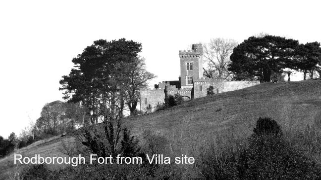
Rodborough, is a Saxon name and although the 'rod' part could come from a personal name it is just as likely that this refers to a rod or pole. This could have been a signalling pole at the current site of Rodborough Fort which, although the current building is 18C, is believed to have been built on an older site. Interestingly, the fort's main entrance points directly towards the Woodchester Villa and is positioned below the high point of the common such that the top of a small tower would just be visible from the Villa. From its prominent position it has good views all around. Was it a lookout post able to signal to the Villa if attackers were around?
A close link, probably roman, between Rodborough Fort and Cirencester also seems to be visible on modern maps. If you were to follow a straight line from St John's church in Cirencester, which was part of the medieval Augustinian Abbey, directly toward Rodborough Fort your first 5 miles would be on Cirencester Park's 'Broad Ride'. You would then continue on a footpath to cross the river Frome in Sapperton woods. Continuing in a straight line, but no longer on current footpaths, you would pass Oakridge Lynch church, The Ram at Bussage, Nether Lypiatt Manor and finally cross the Frome/canal again at Stanton's footbridge between Thrupp and Butterrow. All of these sites are old and in most cases it is not obvious from the terrain why they are there rather than a few hundred yards away. Were there signalling points along the straight line from Cirencester to Rodborough Fort and was there a straight track linking one to the next? This track, if it existed, would have been the natural place to build farmhouses, pubs, churches and bridges. We will probably never know for certain.
Eventually the British Woodchester Estate, both sides of the valley, came under Saxon ownership and we can make a good guess at the name of its first Saxon owner because several places were named after him. He appears to have been Lytel, a common Saxon personal name. His 'worth' or homestead has become Littleworth, his 'brad dune' or 'broad hill pasture' has become Little Britain and his 'lange dune' or 'long hill pasture' has become Little London.
