In previous articles, I have discussed routes which I believe were associated with the Roman occupation of Woodchester and specifically the Roman Villa. In this article, I am looking at other routes which I believe to be old because of the places they connect and because they lie, at least partly, on current footpaths, tracks and roads.
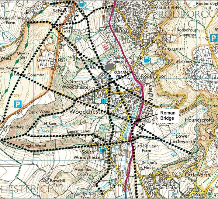
The map below shows these and also includes the following previously discussed routes:-
a) from the Bell at Selsley to the Roman Villa and then down Southfield Road to cross the Nailsworth Steam at a presumed 'Roman Bridge' near Birds Crossing.
b) from the' Roman Bridge' to a second bridge where Gydynapp Lane and St Mary's Hill crossed the steam.
There seems to have been a track from Littleworth, over the 'Roman Bridge', straight up to a long barrow on Selsley Common (suggesting that it is pre-roman) and probably continuing on to the bridge over the River Frome near Stanley Mill. This track passes the point where two current footpaths leave the sharp corner of Church Road and then on to follow the top part of Selsley Road.
In pre-roman times, there was a documented 'Ridgeway' which went along the top of Selsley Common and down to the River Frome, through modern Selsley. Boundary Court is a pinch point on this route, with the ground dropping steeply on both sides. Today two footpaths head from here towards Woodchester; one towards Woodchester Valley Village which I will cover in another article. The second heads towards South Woodchester following the top of the steep edge above Dingle Wood before emerging on to Bospin Lane. At the bottom of the lane, Tower House now blocks the way and the road turns right. By turning left onto the High Street, the original direction is regained passing the Ram. The modern road now turns left but if it were possible to continue without turning, you would soon reach the bottom of Station Road and Little Britain Farm. Surely, this was the ancient route from the Ridgeway to the hamlet of Little Britain.
Modern maps show another path (not a public right of way) which descends steeply through the wood from Boundary Court to the side valley below Dingle Wood and Dark Wood. Here forking right takes you on to Laggar Lane and South Woodchester. Whereas forking left takes you below Dark Wood to emerge on to modern Selsley Road at the bend above Blacklow Close. Continuing in the same direction down the hillside heads directly towards Rooksmoor, at first on Selsley Road. Today Lawns Park (once the grounds of The Lawn) and the Old Rectory block the way, but if they were not there you would continue to and along the current line of trees at the edge of Villa Field and on to Rooksmoor. I suspect that the land acquired for these two large properties straddled an old route from Rooksmoor to Selsley Common, forcing the ancient route to be diverted. Still a problem today with landowners and councils believing our heritage is not important.
The route taken by Water Lane is odd because of the large bend it has half way along which does not seem to be required by the terrain. The best explanation seems to be that there was an old track heading up from the bottom of Bear Hill to go round the 'nose' of Selsley Common at half height on the modern day road 'The Grove'. Looking in more detail, this assumed track started at the bottom of Bear Hill and headed up the hillside in a NW direction through Pauls Rise to Selsley Road. It then crossed the field on the modern footpath, passing the pond in Lawns Park and continued up to the modern Water Lane joining it just below Water Lane Farm. I surmise that when the land for The Lawn was acquired the old track was split with two branches forming. One branch went to the right, following the modern footpath between Lawns Park and the Old Priory and diagonally across field, over the stream and on to Water Lane. The left branch first followed the previously mentioned track up to Boundary Court then turned sharply right along Water Lane (the western boundary of The Lawn) to head directly to The Grove via a bridge over the stream. Later perhaps the bridge collapsed, so travellers and merchants had to travel upstream to find a convenient crossing place before they headed back to the old track. Presumably the bridge was never rebuilt and Water Lane follows this diverted route today. The stream still crosses over and under the road!
For completeness I have also shown the route between North and South Woodchester which I will discuss this in the next article.
