Roman Tracks in Woodchester
In the last edition of Woodchester word we were asked 'Is this a Roman road?' referring to the track heading from the old churchyard towards the Bell at Selsley. Well it is not modern. It is clearly shown on the 1st Ordnance survey of this area, drawn in 1882. Nevertheless, 134 years old does not make it Roman, so we have to look for other evidence. This track has, in parts, created quite a deep hollow, evidence of significant traffic over the centuries, and as it approaches Selsley to become Bell Lane it runs between two old hedges, again suggesting great age. So it must have been there for centuries, but was it Roman?
As we all know Woodchester was the site of a large Roman Villa in the 4th Century AD. Villas at this time were not just stately homes, rather they were the centres of big farm estates. We don't know how large the Roman Woodchester estate was, but in Anglo-Saxon times Woodchester was much bigger than today. It included what we would now call Woodchester, Selsley, Nympsfield, Nailsworth, Rodborough, Brimscombe and probably Amberley as well. Experts assume that it would have been at least as large in Roman times. As a farm estate it would have had a significant agricultural surplus to sell to nearby towns, such as the military centre at Gloucester
To get to Gloucester the Romans would have sought out the 'best' route and, as conquerors, they would have been able to make tracks wherever they wished, however they would still have had to deal with two big problems. First the valleys of the Nailsworth stream and the river Frome were marshy so they could not go along the bottom of the valley like the A46 does today. Secondly, they would want to minimise the amount of climbing. Our hillsides are very steep!
Looking at a map, their most obvious route would be to take a straightish line from the villa over a reasonably low part of the north end of Selsley common and head for what is now Ebley Mill to cross the Frome. Why that point? Well if they had chosen to head further east, they would have had to cross the Nailsworth stream as well as the river Frome. Not a good idea! Whereas, if they had chosen a point further west there would have been more marshy land to cross. Conveniently, crossing near Ebley Mill would have put them on a heading directly towards the gap between Doverow Hill and Maiden hill at Far Westrip from where they could continue north to Gloucester on flat land along the side of the Cotswold edge.
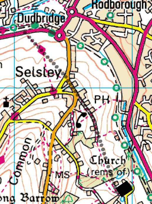
This 'best' route is shown on the map. It goes along the current footpath from the Villa (old churchyard) up to the Bell at Selsley and then continues, in the same direction, down Selsley Hill and at the junction with New Road leaves the modern road and heads down the hillside. As it approaches the Ebley Bypass and the river Frome it merges with a current public footpath and crosses the Frome at what probably became the Saxon ford at Dudbridge. This is why I think the footpath to the Bell is Roman.
In the last edition of Woodchester word we were asked 'Is this a Roman road?' referring to the track heading from the old churchyard towards the Bell at Selsley. Well it is not modern. It is clearly shown on the 1st Ordnance survey of this area, drawn in 1882. Nevertheless, 134 years old does not make it Roman, so we have to look for other evidence. This track has, in parts, created quite a deep hollow, evidence of significant traffic over the centuries, and as it approaches Selsley to become Bell Lane it runs between two old hedges, again suggesting great age. So it must have been there for centuries, but was it Roman?
As we all know Woodchester was the site of a large Roman Villa in the 4th Century AD. Villas at this time were not just stately homes, rather they were the centres of big farm estates. We don't know how large the Roman Woodchester estate was, but in Anglo-Saxon times Woodchester was much bigger than today. It included what we would now call Woodchester, Selsley, Nympsfield, Nailsworth, Rodborough, Brimscombe and probably Amberley as well. Experts assume that it would have been at least as large in Roman times. As a farm estate it would have had a significant agricultural surplus to sell to nearby towns, such as the military centre at Gloucester
To get to Gloucester the Romans would have sought out the 'best' route and, as conquerors, they would have been able to make tracks wherever they wished, however they would still have had to deal with two big problems. First the valleys of the Nailsworth stream and the river Frome were marshy so they could not go along the bottom of the valley like the A46 does today. Secondly, they would want to minimise the amount of climbing. Our hillsides are very steep!
Looking at a map, their most obvious route would be to take a straightish line from the villa over a reasonably low part of the north end of Selsley common and head for what is now Ebley Mill to cross the Frome. Why that point? Well if they had chosen to head further east, they would have had to cross the Nailsworth stream as well as the river Frome. Not a good idea! Whereas, if they had chosen a point further west there would have been more marshy land to cross. Conveniently, crossing near Ebley Mill would have put them on a heading directly towards the gap between Doverow Hill and Maiden hill at Far Westrip from where they could continue north to Gloucester on flat land along the side of the Cotswold edge.
This 'best' route is shown on the map. It goes along the current footpath from the Villa (old churchyard) up to the Bell at Selsley and then continues, in the same direction, down Selsley Hill and at the junction with New Road leaves the modern road and heads down the hillside. As it approaches the Ebley Bypass and the river Frome it merges with a current public footpath and crosses the Frome at what probably became the Saxon ford at Dudbridge. This is why I think the footpath to the Bell is Roman.
