Roman Tracks in Woodchester - Part 2
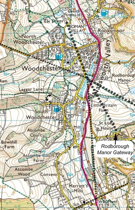
In the last edition of Woodchester Word, I wrote about the track heading north from the Roman Villa towards Selsley and then probably on to Gloucester. This time, I am looking that how the Romans might have travelled from the villa to Cirencester - the administrative capital in this part of England. There would have been two obstacles to contend with, first crossing the Nailsworth Stream and second climbing up to the Cotswold plateau. Remember travelling along the valley, as we do now, was not an option as it was too marshy.
Looking at a map it is clear that northern end of Southfield Road, the bit from Selsley Road to Birds Crossing, is straight and seems to come from the villa and is aligned with the Roman Pavement and with the old Church. For this reason Southfield Road is widely believed to be the driveway of the villa. If you could continue in the same direction south down the villa driveway, you would cross the Nailsworth Stream about 50m south of Birds Crossing. Significantly, this is also the point where the present day footpath from Lower Littleworth down the field to the bus stop near Manor Gardens would, if it continued, also cross the stream.
If, having come down the villa driveway, you crossed the Nailsworth Stream and continued in virtually the same direction you would enter the field just across the A46. Continuing, you would cross the little stream above Little Britain farm and be heading directly towards the Rodborough Manor ornamental gateway on a route which is along a field boundary. Although this route is not a track or footpath today it is shown clearly as a track/road on maps published around 1830 and was the access route to St Loe's School, now St Loes House. The ornamental gateway is interesting and confusing. It is usually described as a folly and although it would be visible from Rodborough Manor house on Bear Hill, it points towards Woodchester Villa and not the Manor House, so it seems to be related to the villa or the old track. My preferred explanation is that the track was Roman and the folly was built on the site of a Roman gateway to the Villa estate. Also of note is that this route passes close to a Roman brickyard, described as being above the sunken lane leading down to Little Britain farm. Interestingly, the original, 8th century, Anglo-Saxon name for St Chloe was Sentodleag, which probably meant 'Burnt clearing'. The name successively changed to Sengetlege through Sengedleah to Seynckley and finally St Chloe.
Continuing from the ornamental gateway would take you to Minchinhampton common, near the Black Horse Pub, partly on current footpaths. Cirencester could now be reached on the flat.
I have also shown on the map two interesting observations. Firstly, following the line of the top of Selsley Road takes you directly to the crossing point on the Nailsworth Stream having first passed through the corner of Church Lane and South Bank. Was this an old route which is no longer visible on the ground? Secondly, following a straight line from the stream crossing point to the next likely ancient crossing point, where Gydynapp Lane and St Mary's Hill would have met, takes you on higher ground along part of Culver Hill and also on some current footpaths just above Merrett's Mill. These are better seen on a coloured OS map. As an aside, does anyone know the derivation of Gydynapp? It sounds Celtic to me.
