From North to South Woodchester
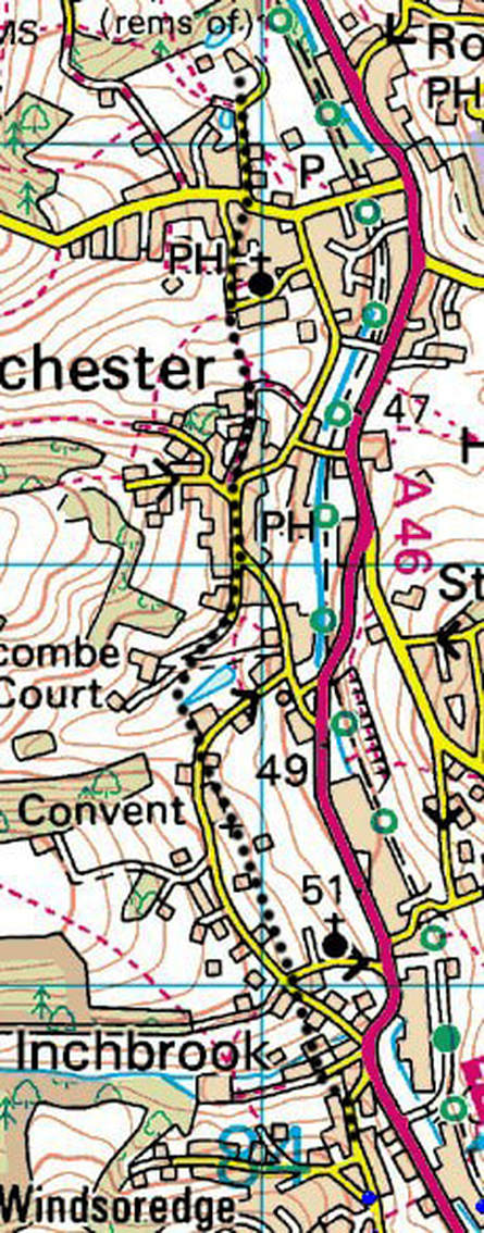
This will be the last of my articles about where I believe the Roman and medieval routes were in Woodchester. It covers the route from the old Parish Church (The Roman Villa) through South Woodchester to Inchbrook. The route, as it was the 1840s, was elegantly described by the Rev. Henry Housman, a relation of A E Housman, and reproduced in a Woodchester Word Article several years ago as 'From The Story of Our Museum and What it Taught Us by Rev Henry Housman published in 1881’. This can be seen at woodchesterhistory.weebly.com.
In the medieval period the centre of Woodchester was around the Church and the Manor House, now the Old Priory, and the route out of the village to the south would have been along the side of the valley high enough up to avoid both the marshy ground at the bottom of the valley and also its steep slopes. I think it would have followed modern day Church Lane, with 'The Lawn' on the right, then, on reaching Selsley Road, I suspect it went straight across and continued in the same direction along the top boundary of Upper Berrymore Cottage. Then, back on Church Road, it continued above the ‘new’ church all the way to South Woodchester High Street on the current footpath over 'Little Hill'. If this interpretation is correct the 'Royal Oak' was not on this route, so the diversion it is on must have been in place before it was built in the 17th century.
At the south end of the High Street the way would have continued on Atcombe Road and then on the driveway of Atcombe Court before diverging from it somewhere near the house to cross the valley near the top of the Frogmarsh millpond. Next it would have contoured around the valley to pass just above Atcombe Farmhouse to reach Convent Lane. Observant villagers will have noticed that Atcombe Farmhouse is at a strange angle to the current road and that this would explain why.
The route would then have continued along the present day Convent Lane, probably diverging from it near to the Convent to follow the Convent's alignment along the back of the gardens on the east side of the lane. At roughly the position of the present junction with St Mary's Hill and Park Lane it probably continued south crossing the side valley just below Woodchester Valley Village to emerge onto Inchbrook Hill at the bend where Inchbrook House stands now at a strange angle to the current road, but appropriately aligned to this old route.
